Turn a Terrain into a Contoured Map
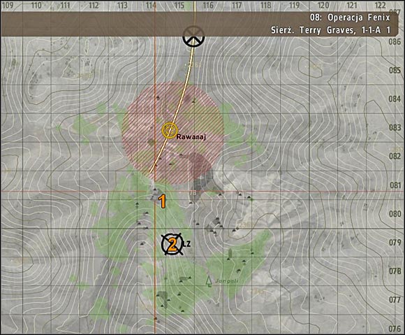
Is there a way to create a height-contoured map from a Unity Terrain other than to manually paint over it? Something like Arma to this effect:
I've tried using an exported heightmap but Photoshop-fu can only take one so far.
Updated Post
Figured I may aswell try it in Unity... (Output shown on plane. Uses alpha channel so lines can be overlaid)
Code below image.
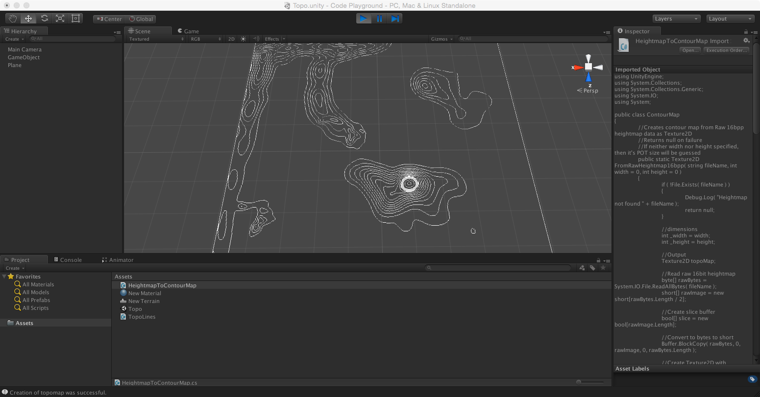
Listing for HeightmapToContourMap.cs
 using UnityEngine;
 using System.Collections;
 using System.Collections.Generic;
 using System.IO;
 using System;

 public class ContourMap
 {
     //Creates contour map from Raw 16bpp heightmap data as Texture2D
     //Returns null on failure
     //If neither width nor height specified, then it's POT size will be guessed
     public static Texture2D FromRawHeightmap16bpp( string fileName, int width = 0, int height = 0 )
     {
         if ( !File.Exists( fileName ) )
         {
             Debug.Log( "Heightmap not found " + fileName );
             return null;
         }

         //dimensions
         int _width = width;
         int _height = height;

         Color32 bandColor =  new Color32(255, 255, 255, 255);
         Color32 bkgColor = new Color32(0, 0, 0, 0);

         //Output
         Texture2D topoMap;

         //Read raw 16bit heightmap
         byte[] rawBytes = System.IO.File.ReadAllBytes( fileName );
         short[] rawImage = new short[rawBytes.Length / 2];

         //Create slice buffer
         bool[] slice = new bool[rawImage.Length];

         //Convert to bytes to short
         Buffer.BlockCopy( rawBytes, 0, rawImage, 0, rawBytes.Length );

         //Create Texture2D with estimated or specified width
         if ( _width == 0 || _height == 0 )
         {
             _width = (int)Math.Sqrt( rawImage.Length ); //Estimated width/height
             _height = _width;
             topoMap = new Texture2D( _width, _height );
         }
         else
         {
             topoMap = new Texture2D( _width, _height );
         }

         topoMap.anisoLevel = 16;

         //Set background
         for (int x = 0; x < _width; x++)
         {
             for (int y = 0; y < _height; y++)
             {
                 topoMap.SetPixel( x, y, bkgColor );
             }
         }

         //Initial Min/Max values for signed 16bit value
         int minHeight = 32767;
         int maxHeight = -32767;

         //Find lowest and highest points
         for ( int i = 0; i < rawImage.Length; i++ )
         {
             if ( rawImage[ i ] < minHeight )
             {
                 minHeight = rawImage[ i ];
             }
             if ( rawImage[ i ] > maxHeight )
             {
                 maxHeight = rawImage[ i ];
             }
         }

         Debug.Log("Min: " + minHeight.ToString() + ", Max: " + maxHeight.ToString());

         //Create height band list
         int bandDistance = maxHeight / 12; //Number of height bands to create

         List<int> bands = new List<int>();

         //Get ranges
         int r = minHeight + bandDistance;
         while ( r < maxHeight )
         {
             bands.Add( r );
             r += bandDistance;
         }

         //Draw bands
         for ( int b = 0; b < bands.Count; b++ )
         {

             //Get Slice
             for ( int i = 0; i < rawImage.Length; i++ )
             {
                 if ( rawImage[ i ] >= bands[ b ] )
                 {
                     slice[ i ] = true;
                 }
                 else
                 {
                     slice[ i ] = false;
                 }
             }

             //Detect edges on slice and write to output
             for ( int y = 1; y < _height - 1; y++ )
             {
                 for ( int x = 1; x < _width - 1; x++ )
                 {
                     if ( slice[ y * _width + x ] == true )
                     {
                         if ( slice[ y * _width + ( x - 1 ) ] == false || slice[ y * _width + ( x + 1 ) ] == false || slice[ ( y - 1 ) * _width + x ] == false || slice[ ( y + 1 ) * _width + x ] == false )
                         {
                             topoMap.SetPixel( x, y, bandColor );
                         }
                     }
                 }
             }

         }

         topoMap.Apply();

         //Return result
         return topoMap;
     }
 }
Listing for TopoLines.cs
 using UnityEngine;
 using System.Collections;

 public class TopoLines : MonoBehaviour
 {
     public string heightmapPath = "/Users/dave/desktop/terrain.raw";

     public Texture2D topoMap;

     public Material outputMaterial;

     void Start()
     {
         topoMap = ContourMap.FromRawHeightmap16bpp(heightmapPath);

         if (topoMap == null)
         {
             Debug.Log("Creation of topomap failed.");
         }
         else
         {
             Debug.Log("Creation of topomap was successful.");
         }

         if (outputMaterial != null)
         {
             outputMaterial.mainTexture = topoMap;
         }
     }
 }
How would this be implemented? While building the level? During runtime?
Also regarding drawing the overlay, were you referring to a graphics program? or can unity edit images through scripting? Sorry about all the questions and thanks for the reply.
Interesting. I'll see if I can get something similar working for Unity and check back here. $$anonymous$$uch appreciated.
Had a bit of free time so did another example which uses 16bit raw height map data which is a more likely scenario. It is also considerably faster.
Figured it out...
After creating Texture2D clear background;
 //Set background
         for (int x = 0; x < _width; x++)
         {
             for (int y = 0; y < _height; y++)
             {
                 topo$$anonymous$$ap.SetPixel( x, y, bkgColor );
             }
         }
Then remove the else section from edge detection so it looks like so;
 if ( slice[ y * _width + ( x - 1 ) ] == false || slice[ y * _width + ( x + 1 ) ] == false || slice[ ( y - 1 ) * _width + x ] == false || slice[ ( y + 1 ) * _width + x ] == false )
                         {
                             topo$$anonymous$$ap.SetPixel( x, y, bandColor );
                         }
I also updated code listing above with fix and removed the unnecessary slice allocation in the band loop. Same slice buffer can be reused.
This is a modified script from the excellent answer by Dave29483 for creating a contour map texture from a terrain. Add the function to that class, or just use the class as below.
Call with :
 ContourMap.FromTerrain( terrain ) // use default number of bands and colours
 ContourMap.FromTerrain( terrain, numberOfBands ) // assign number of bands, use default colours
 ContourMap.FromTerrain( terrain, numberOfBands, bandColor, bkgColor ) // assign number of bands and colours
modified ContourMap.cs :
 using UnityEngine;
 using System.Collections;
 using System.Collections.Generic;


 public class ContourMap : MonoBehaviour
 {
     // Creates contour map from terrain heightmap data as Texture2D

     // use default colours and optional parameter numberOfBands
     public static Texture2D FromTerrain( Terrain terrain, int numberOfBands = 12 )
     {
         return FromTerrain( terrain, numberOfBands, Color.white, Color.clear );
     }

     // define all parameters
     public static Texture2D FromTerrain( Terrain terrain, int numberOfBands, Color bandColor, Color bkgColor )
     {
         // dimensions
         int width = terrain.terrainData.heightmapWidth;
         int height = terrain.terrainData.heightmapHeight;

         // heightmap data
         float[,] heightmap = terrain.terrainData.GetHeights( 0, 0, width, height );

         // Create Output Texture2D with heightmap dimensions
         Texture2D topoMap = new Texture2D( width, height );
         topoMap.anisoLevel = 16;

         // array for storing colours to be applied to texture
         Color[] colourArray = new Color[ width * height ];

         // Set background
         for ( int y = 0; y < height; y++ )
         {
             for ( int x = 0; x < width; x++ )
             {
                 colourArray[ (y * width) + x ] = bkgColor;
             }
         }

         // Initial Min/Max values for normalized terrain heightmap values
         float minHeight = 1f;
         float maxHeight = 0;

         // Find lowest and highest points
         for ( int y = 0; y < height; y++ )
         {
             for ( int x = 0; x < width; x++ )
             {
                 if ( minHeight > heightmap[ y, x ] )
                 {
                     minHeight = heightmap[ y, x ];
                 }
                 if ( maxHeight < heightmap[ y, x ] )
                 {
                     maxHeight = heightmap[ y, x ];
                 }
             }
         }

         // Create height band list
         float bandDistance = ( maxHeight - minHeight ) / (float)numberOfBands; // Number of height bands to create

         List< float > bands = new List< float >();

         // Get ranges
         float r = minHeight + bandDistance;
         while ( r < maxHeight )
         {
             bands.Add( r );
             r += bandDistance;
         }

         // Create slice buffer
         bool[,] slice = new bool[ width, height ];

         // Draw bands
         for ( int b = 0; b < bands.Count; b++ )
         {
             // Get Slice
             for ( int y = 0; y < height; y++ )
             {
                 for ( int x = 0; x < width; x++ )
                 {
                     if ( heightmap[ y, x ] >= bands[ b ] )
                     {
                         slice[ x, y ] = true;
                     }
                     else
                     {
                         slice[ x, y ] = false;
                     }
                 }
             }

             // Detect edges on slice and write to output
             for ( int y = 1; y < height - 1; y++ )
             {
                 for ( int x = 1; x < width - 1; x++ )
                 {
                     if ( slice[ x, y ] == true )
                     {
                         if (
                             slice[ x - 1, y ] == false ||
                             slice[ x + 1, y ] == false ||
                             slice[ x, y - 1 ] == false ||
                             slice[ x, y + 1 ] == false )
                         {
                             // heightmap is read y,x from bottom left
                             // texture is read x,y from top left
                             // magic equation to find correct array index
                             int ind = ( ( height - y - 1 ) * width ) + ( width - x - 1 );

                             colourArray[ ind ] = bandColor;
                         }
                     }
                 }
             }

         }

         // apply colour array to texture
         topoMap.SetPixels( colourArray );
         topoMap.Apply();

         // Return result
         return topoMap;
     }
 }
example TopoLines.cs :
 using UnityEngine;
 using System.Collections;


 public class TopoLines : MonoBehaviour
 {
     public Terrain terrain;

     public int numberOfBands = 12;

     public Color bandColor = Color.white;
     public Color bkgColor = Color.clear;

     public Renderer outputPlain;

     public Texture2D topoMap;


     void Start()
     {
         GenerateTopoLines();
     }

     void Update()
     {
         if ( Input.GetMouseButtonDown(0) )
         {
             GenerateTopoLines();
         }
     }

     void GenerateTopoLines()
     {
         //topoMap = ContourMap.FromTerrain( terrain );
         //topoMap = ContourMap.FromTerrain( terrain, numberOfBands );
         topoMap = ContourMap.FromTerrain( terrain, numberOfBands, bandColor, bkgColor );

         if ( outputPlain )
         {
             outputPlain.material.mainTexture = topoMap;
         }
     }
 }
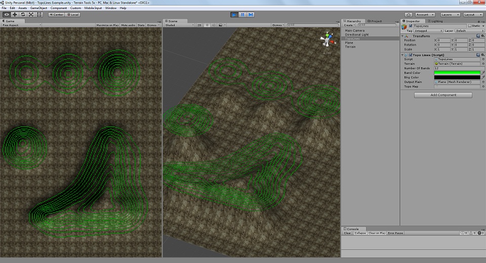
Image from test. Change values in runtime and left-mouse in scene to observe :
Thanks a lot !!
This end with weird odd texture resolution but it works like a charm !!
The odd texture resolution is because Unity terrain heightmaps are 2^n + 1 (eg 257, 513, 1025), more info : http://docs.unity3d.com/$$anonymous$$anual/terrain-OtherSettings.html (scroll down to Resolution)
Heightmap Resolution : Pixel resolution of the terrain’s heightmap (should be a power of two plus one, eg, 513 = 512 + 1).
I chose to leave it, to return a texture with the true full range of heights. However if you wish the texture to be 2^n (256, 512, 1024) then the lines that set the width and height can be modified like this :
 // dimensions
 int width = terrain.terrainData.heightmapWidth - 1;
 int height = terrain.terrainData.heightmapHeight - 1;
Unity is strange in how it uses different coordinate systems (screen, texture, heightmap all have different origins and axis?!!). I had some trouble myself with this while converting that script. You see the comment "// magic equation to find correct array index" ;)
All I can suggest is some trial and error to find the right index calculation. If both axis are flipped, try :
int ind = (y * width) + x;
or other combinations thereof :
 int ind = ((height - y - 1) * width) + x; // flip y, keep x
 int ind = (y * width) + (width - x - 1); // keep y, flip x
I am very new to unity but would like to implement this. Is there somewhere where I can get more instruction or even a sample project with this already setup?
Thanks.
I've made an asset "Wire Terrain" and it can create mesh contours from terrain: https://assetstore.unity.com/packages/tools/modeling/wireterrain-94895
