[Help Needed] Trying to flatten terrain in terrain centre via script.
I am trying to modify my terrain height values in order to create a nice flat area in the middle of terrain , with the other hill/mountain like values still intact around the area. So far all is well , apart from I have reached a point where I get an error:
ArgumentException: Trying to access out of bounds height information.
I have checked this , and based my solution around its structure but with no full avail so far!
My first code file (ScriptCreateBuildZone) is where the error occurs (On line 60) and then stops , I just cannot understand where it is trying to access as the I believe that the terrain values(See in DebugLog screenshot at the bottom) are okay. Then again I might be horribly wrong. Here is the script:
 using UnityEngine;
 using System.Collections;

 public class ScriptCreateBuildZone : MonoBehaviour {

     Terrain terrMain;
     int hmWidth;
     int hmHeight;
     int terrPosX;
     int terrPosY;
     int buildZoneSize = 50;
     int finalHeight;

     // Use this for initialization
     void Start () {
         //terrMain = GameObject.Find("Terrain(Clone)") as Terrain;
         Destroy(GameObject.Find("Terrain(Clone)"));
         terrMain = Terrain.activeTerrain;
         hmWidth = terrMain.terrainData.heightmapWidth;
         hmHeight = terrMain.terrainData.heightmapHeight;

         Debug.Log ("HeightMap Width and Height:" + hmWidth + "," + hmHeight);

     }

     // Update is called once per frame
     void Update ()
     {

         Func();

     }

     void Func()
     {
         Vector3 tempCoord = (transform.position - terrMain.gameObject.transform.position);

         Debug.Log ("Temp coords are:" + tempCoord.x + "," + tempCoord.y + "," + tempCoord.z);

         Vector3 coord;
         coord.x = tempCoord.x / terrMain.terrainData.size.x;
         coord.y = tempCoord.y / terrMain.terrainData.size.y;
         coord.z = tempCoord.z / terrMain.terrainData.size.z;

         Debug.Log ("Terrain data XYZ Positions are:" + terrMain.terrainData.size.x + "," + terrMain.terrainData.size.y + "," + terrMain.terrainData.size.z);

         Debug.Log ("coords are:" + coord.x + "," + coord.y + "," + coord.z);

         terrPosX = (int) (coord.x * hmWidth);
         terrPosY = (int) (coord.z * hmHeight);

         //terrPosX = (int)tempCoord.x ;
         //terrPosY = (int)tempCoord.z ;

         Debug.Log ("TerrainPos's are:" + terrPosX + "," + terrPosY);


         int offset = buildZoneSize / 2;
         print ("Getting hieghts for hieghtmap...");
         float[,] heights = terrMain.terrainData.GetHeights(terrPosX-offset,terrPosY-offset,buildZoneSize,buildZoneSize); //<- ERROR OCCURS HERE!
         print ("getHeights Successful.");
         Debug.Log (heights);
         for (int i = 0; i < buildZoneSize; i++)
         {
             for (int j = 0; j < buildZoneSize; j++)
             {
                 heights [i, j] = finalHeight;
                 Debug.Log (finalHeight);
             }
         }
         // go raising the terrain slowly
         finalHeight += finalHeight; //Time.deltaTime;

         terrMain.terrainData.SetHeights(terrPosX-offset,terrPosX-offset,heights);
         Destroy (this.gameObject);
     }
 }
The second script that may also be of importance is the one where my terrain is instantiated with its values(ClassTerrain). NOTE: I am using the TerrainToolkit asset pack which is why i have those values in the if statements , works great! Second script:
 public class ClassTerrain : MonoBehaviour {

     //Objects of the terrain
     GameObject terrObj ;
     public GameObject terrBuildZone; //= GameObject.CreatePrimitive(PrimitiveType.Cylinder);

     //Variables for future manipulation
     TerrainData terrData;
     Terrain terrMain;
     int hmWidth;
     int hmHeight;
     int terrPosX;
     int terrPosY;
     int buildZoneSize = 50;
     int finalHeight;


     //public Terrain terrain;
     //Data for the terrain
     //Numeric Variables
     public int terrainX = 10000;
     public int terrainZ = 10000;
     int heightMapWidth;
     int heightMapHeight;
     //SET UP CLIMATE DETAILS HERE
     enum ClimateType
     {
         tropicaldry,
         mediteranean,
         subtropical,
         marinewestcoast,
         arid,
         highland

     };

     ClimateType ct;


     void Start ()
     {
         Init();
         ConstructMap ();
     }


     void Update ()
     {


     }

     void Init()
     {

         short climateChoice = 1;
         //terrObj.layer = 8;
         TerrainData temp_terrData = new TerrainData();
         temp_terrData.size = new Vector3 (terrainX, 1000, terrainZ);
         terrObj = Terrain.CreateTerrainGameObject(temp_terrData);

         Vector3 position = new Vector3 (0, 0, 0); //the ingame position you want your terrain at
         terrObj = Instantiate(terrObj, position, Quaternion.identity) as GameObject;

         //DO CASE STATEMENT
         switch (climateChoice)
         {
         case  1:
                 ct = ClimateType.tropicaldry;
                                         break;
         case  2:
                 ct = ClimateType.mediteranean;
                                         break;
         case  3:
                 ct = ClimateType.subtropical;
                                         break;
         case  4:
                 ct = ClimateType.marinewestcoast;
                                         break;
         case  5:
                 ct = ClimateType.arid;
                                         break;
         case  6:
                 ct = ClimateType.highland;
                                         break;
         }

         terrMain = Terrain.activeTerrain;

         hmWidth = terrMain.terrainData.heightmapWidth;
         hmHeight = terrMain.terrainData.heightmapHeight;

     }


     void ConstructMap()
     {
         TerrainToolkit tt = terrObj.AddComponent <TerrainToolkit>() as TerrainToolkit;
         terrObj = GameObject.Find("Terrain(Clone)");
         terrObj.gameObject.GetComponent<TerrainToolkit> ().PerlinGenerator (3, 0.5f, 9, 1.0f);


         if (ct == ClimateType.tropicaldry)
         {
             tt.PerlinGenerator(3, 0.5f, 9, 1.0f);

             Instantiate (terrBuildZone);


         }

         else if (ct == ClimateType.mediteranean)
         {
             tt.PerlinGenerator(2, 1.0f, 8, 1.0f);
             //pos 5285,310,4755
             //scale 7500,10,7500
         }

         else if (ct == ClimateType.subtropical)
         {
             tt.PerlinGenerator(2, 1.0f, 5, 1.0f);
             //pos 4865,180,5030
             //scale 7500,100,7500
         }

         else if (ct == ClimateType.marinewestcoast)
         {
             tt.PerlinGenerator(3, 0.5f, 3, 1.0f);
             //pos 5025 , 100 , 5500
             //scale 7500 , 1 , 7500
         }

         else if (ct == ClimateType.arid)
         {
             tt.PerlinGenerator(8, 0.07f, 9, 1.0f);
             //pos 4750, 50 , 5210
             //scale 7500, 10 , 7500
         }

         else if (ct == ClimateType.highland)
         {
             tt.PerlinGenerator(5, 1.0f, 7, 1.0f);
             //pos 4800 , 400 ,4800
             //scale 7500 , 100 , 7500

         }

     }

 }
My terrain values may be the issue , but again Im not sure. Here is the debug log for assistance: 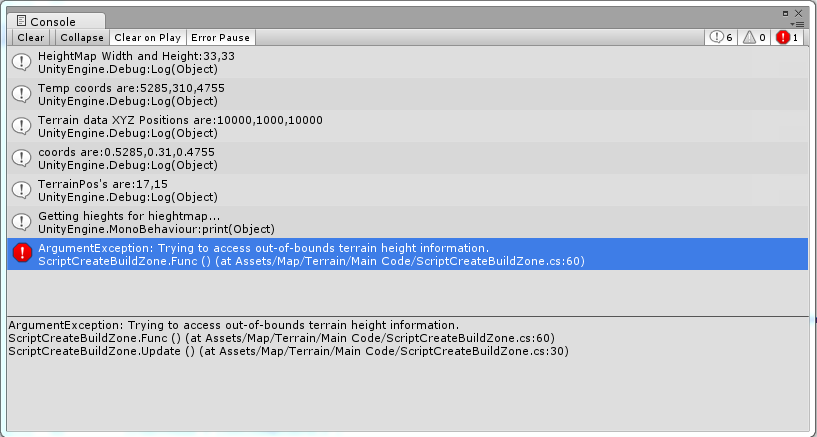
If any other info is needed , please ask! Thanks
